
Sidewinder Low Level Flying Photography
The R-2508 “Sidewinder” Low Level Route
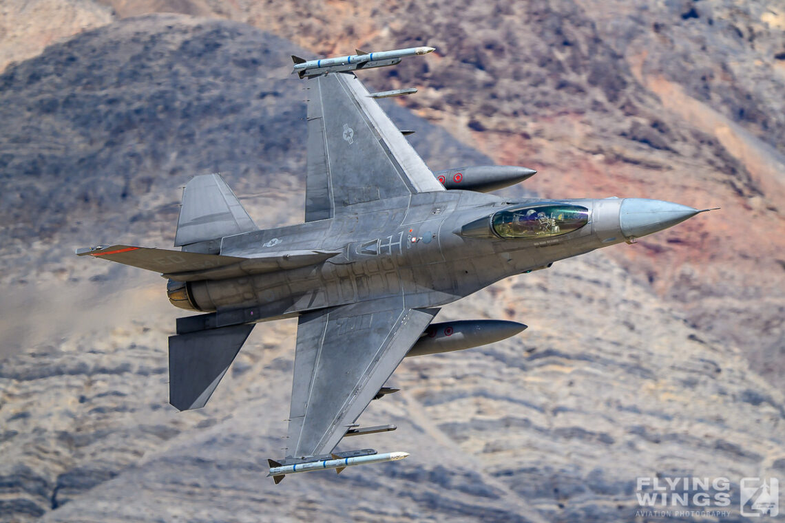
The “Sidewinder” is one of the key low-level military training routes within the R-2508 Special Use Airspace Complex in Southern California. This route is primarily used by fast jets such as F/A-18 Hornets and F-35 Lightning IIs for high-speed, low-altitude training missions. Aircraft can travel in excess of 500 knots as low as 200 feet AGL. In fact, parts of this military training routes have a base altitude designated as “surface,” and military aircraft may operate right on the deck!
Running through rugged terrain near the Kern River Valley and adjacent Sierra Nevada foothills and the Death Valley, the Sidewinder route offers pilots challenging natural corridors ideal for practicing tactical maneuvers at treetop height. For aviation photographers and plane spotters, the Sidewinder route provides exciting opportunities to capture jets flying just above canyon ridges and winding river valleys.
As the route passes along the Sequoia and Death Valley National Parks, there is not such a thing as ‘the’ typical photo from the Sidewinder, but your motives and backdrops will vary widely, depending on the location that you have chosen. Within two or three days, you can get everything from snow covered trees to sand dunes. Actually, most of the photos presented on this page were shot during one week on spring 2025.
The Sidewinder route is pictured below. It is flown in “clockwise” direction only (A -> M), but it has to be noted that aircraft can drop in and leave it at any of the waypoints. Therefore jets passing through the Sequoia NP part (A -> B/C) do not necessarily need to continue along Owen’s Valley (C -> E) or even continue to Death Valley (F -> J).


The JEDI Transition (point C – J) through Rainbow (or Star Wars) Canyon made low flying photography in California very popular. Star Wars offered one spot that was easily accessible by car and did not involve any hiking at all. After the deadly crash of a US Navy Super Hornet in July 2019, military jets are not allowed to fly low through this canyon any more. Therefore other possibilities had to be found photograph low flying jets in California. Newly discovered spots offer more possibilities, but also more challenges as most of them are not easily accessible as it has been Star Wars canyon, which turned into a ‘Low Level Drive-In’ before its shut down.
Later paragraphs will in more detail describe some of the spots that I have tried out myself.
Important notes: The timing and frequency of flights on the Sidewinder route vary daily based on military training schedules and weather conditions. Passes can be very fast and unpredictable, so patience and vigilance are key for successful spotting, as is a a radio scanner set to 315.9 MHz. Luck and patience will be your friend during a trip to the Sidewinder!
Point A-B: Kern River, Low-Flying Jets & Sierra Backdrops
If you’re a fan of military aviation photography and dramatic natural landscapes, the area north of Kernville, California, offers a rare combination of both. Along the Upper Kern River, photographers can sometimes catch low-flying military jets roaring through the canyons — with granite cliffs, pine-covered slopes, and the roaring river below providing an unforgettable backdrop.
Where to Spot Military Jets
The airspace north of Kernville lies on the edge of the R-2508 military operations area, used for high-speed training flights out of Edwards AFB, China Lake, and Lemoore NAS. Though less predictable than other locations like the now-gone Rainbow Canyon, this section of the Sierra foothills sees:
- F/A-18 Super Hornets
- F-35 Lightning IIs
- C-17s and other support aircraft
- T-38 Talons
Best chances occur on weekday mornings, especially near remote locations like Fairview, Dry Meadow Creek, and the Johnsondale Bridge. These natural canyons act like corridors, and when jets appear, they do so suddenly — often below ridge level or hugging the contours of the terrain.
By far the most popular spot is located close to the Calkins Flat Dispersed Area (Google Maps), from where you need to hike up a ridge through rough and rocky terrain. It is so popular that there is now even a small footpath clearly visible that will show you the way up. But be aware, the descend will be steep and slippery! Hiking sticks will be your friends. Recommended only in the morning, as from midday on the jets will mostly be backlit.
Just a bit further North you will find the Packsaddle Trail (Google Maps), which is an official hiking path. The hike leading the way up is a bit longer, but easier to handle on the way up and down. At that spot, the valley is getting narrower, therefore jets tend to pull up at that spot. The chance is given that they are not ‘landlocked’ anymore and you will see their underside. If they stay low, the sights are however spectacular! Give this spot a try as well if you stay in the area for a few days.
Bonus: The natural light in this area is excellent, especially in the early morning when the Sierra granite glows and jet vapor trails are backlit.
If you want to take photos in the afternoon, you have to cross Kern River at the bridge located at McNally’s (Google Maps) and be prepared for an approximately one and a half hour hike South along the River following the Whiskey Flat Trail. The hike is mainly flat, but not very popular, therefore you should be prepared to pass through some undergrowth. Bring a map and ask the locals if bears are in the area (no kidding here!).


Tips for Aviation Photographers
- Bring a telephoto lens (500mm+ recommended) and use a fast shutter speed. Only try panning after your first catches.
- Stay alert — passes are hard to spot but fast. A radio scanner will help you to hear incoming traffic.
- Position yourself above the river on a ridge with wide visibility.
- Patience is key — sightings are unannounced and unpredictable.
- Enjoy the silence and nature when no jets are around!
Kern River Valley low level flying – Photo Gallery


After the Chase: Kern River Brewing Company 🍺
After a long day hiking ridges and scanning the skies, reward yourself back in Kernville with a cold pint at the famous Kern River Brewing Company. This local favorite serves up award-winning craft beers like Just Outstanding IPA and hearty post-hike meals. Their outdoor patio is the perfect place to relax, swap jet-spotting stories, or plan your next photography mission.
Safety and Practical Info
- The roads north of Kernville (Mountain Hwy 99) are winding and narrow — drive carefully especially in the morning and during the cold season.
- There is no cell service in most areas — bring maps or offline GPS.
- Be bear-aware if hiking; pack out all trash and store food safely.
- In spring, high river flow can make some areas dangerous to access.
- Always respect private land boundaries.
Point D: Haystack Hill – Lone Pine’s Hidden Spot for Jet Photography
Just east of Lone Pine, California, in the shadow of the Sierra Nevada, lies an unofficial but well-known landmark among military aviation enthusiasts: Haystack Hill (Google Maps). This isolated rocky formation sits on public desert land and provides elevated views of the Owens Valley and portions of the R-2508 Complex, one of the busiest military flight corridors in the U.S. Haystack is located a bit North of Point D of the Sidewinder Route.
Why Haystack Hill is Popular with Plane Spotters
Haystack Hill offers a unique vantage point for spotting low-flying military aircraft, including F/A-18 Hornets, F-35 Lightning IIs, and sometimes even cargo planes or helicopters on training missions. Under the right conditions, aircraft can fly below the level of the hill or pass by at eye level, creating rare and dramatic photo opportunities for skilled photographers with the right gear.
Many visitors bring DSLR or mirrorless cameras with telephoto lenses (500mm or more) and wait for hours to catch a perfect shot. While aircraft appearances are unpredictable, mornings and weekdays tend to see more activity. Use a radio scanner or live tracking apps for best results, though military flights may not always be visible on public channels.


One big advantage is that the spot can be used throughout the day, as jets can pass it on the East and West. Therefore you can have backlit photos during the whole day. From my own experience, I have mostly seen passes along the West, making Haystack most suitable in the morning. Passes using the Eastern gap do happen, and they will look spectacular on photo and video, but they happen rarely. If being asked, I would say that East/West passes happen 80/20. Flights through the gap are more spectacular though, but I assume that most of them leading to the cool photos have been pre-arranged with the flight crews.
My recommended strategy is to aim for low level passes along the Western side of Haystack in the morning (most jets will use the power line as a visual reference when flying from point D-E), and then go to a location on the Southern side of Haystack around midday (if you decide to descend early, you can easily reach the Kern area in the late afternoon / early evening).
You will be further away for any of the passes on the South side, but at least you will see all of the jets. Still, morning tends to be the best time of the day here.

Safety and Access Warning
- There is no marked trail, and the terrain consists of loose rock, steep inclines, and unstable footing.
- The hill is not maintained, and a fall could easily lead to injury with no nearby emergency services.
- In summer, temperatures soar, and there is no shade or water — heatstroke is a real danger.
- Cell service is spotty or nonexistent.
- Attempt the climb only if you’re physically fit and experienced in backcountry hiking. Do not climb alone!
- Wear sturdy boots and bring plenty of water and sun protection.
Haystack and Owens Valley low level flying – Photo Gallery


Final Thoughts on Haystack
Haystack Hill is not for everyone — it’s rugged, remote, and risky. Personally, I do not like the hike, and even rate it as the most dangerous one of all of the spots along the Sidewinder Route that I describe on this site. It’s a love and hate relationship though, and the most accessible side for the climb of Haystack seems to be Southern one, which is what I tried last time. Therefore, for well-prepared enthusiasts, Haystack offers one of the most unique and dramatic spots in California for photographing low-flying jets against a stunning desert backdrop. But always put safety first and leave no trace.
Point G: Eureka Dunes
How to Get from Big Pine to Eureka Dunes – Death Valley National Park Travel Guide
Planning a trip to the remote and spectacular Eureka Dunes in Death Valley National Park? Here’s everything you need to know about driving from Big Pine, California to the Eureka Dunes — one of the most unique and isolated destinations in the park.


Driving Directions from Big Pine to Eureka Dunes
The route from Big Pine to Eureka Dunes covers approximately 50 miles and takes around 2 to 2.5 hours, depending on road conditions.
- Start in Big Pine, CA, and head east on California Highway 168.
- After about 2 miles, turn south onto Death Valley Road. Depending on the road condition, you might need to continue on Hwy 168 up to Oasis and only then take a right turn on the dirt road.
- Drive approximately 27 miles, then turn onto Eureka Valley Road — an unpaved dirt road leading to the dunes.
- Park you car at Eureka Dunes Dry Camp (Google Maps)
Road and Vehicle Recommendations
- High-clearance vehicles are strongly recommended due to rocky and sandy sections.
- 4WD may be necessary during or after rain or in soft sand. At least you should have a car with high ground clearance.
- There is no cell service, so carry a detailed map or GPS (offline capable).
- Check road and weather conditions before your trip — especially in summer, when extreme heat can be dangerous.
- Bring plenty of water, food, and emergency supplies.
What to Expect at Eureka Dunes
Located in the remote Eureka Valley, the dunes are some of the tallest sand dunes in North America. Visitors are rewarded with incredible solitude, sweeping views, and the chance to hear the dunes’ mysterious booming sounds — a rare natural phenomenon caused by shifting sand.
Low flying jets will pass around the Dunes at low level from the North-East and continue South. As they will be in the turn, you can get some nice topside photos, but not every jet will stay long enough low enough that you have it landlocked. From my experience during two days spent there, movements will be low. I have seen a maximum of four low passes on a single day, hearing some jets leaving the route just before point F, which was disappointing. Luckily, the experience driving there and the scenic sights made up for it. And I knew beforehand that Luftwaffe Tornados were supposed to fly by that day as well…
Eureka Dunes – Low level flying Photo Gallery


A word of caution!
The Eureka dunes reach an impressive height of 680ft (207 meter) and are steep, very steep… Despite being part of the Death Valley NP, the dunes are remotely located in an inhospitable area. Prepare your trip well and do not use the Eureka spot from the end of the spring season until early autumn. Death Valley is the hottest area in North America and temperatures will be unbearable during the day. Even during winter season you will suffer the heat on the Dunes.

Safety advice!
From below, the climb might look quick and easy, but it is not! Especially as you want to bring up your photography gear. To get up you have to partly crawl on all fours, and it’s more like one step forward and two steps back.
I saw several people attempting the climb early in the morning with only a small bottle of water, but they failed. Fortunately, they realized their mistake in time and returned to their car safe and sound, albeit exhausted.
Consider that you will spend your day on the dune without any shadow, therefore be prepared for that. If you see campers on the dry camp, tell them what you are planning to do. They might get worried if they see you hanging out there on the Dune the whole day.
Last but not least: The higher you are on the dunes, the better the chances are that the jets are passing below the rim of the opposite hillside. But this will also bring you further back and you will see quite some heat haze when using a 600mm lens. Also take care of the sand. It will be everywhere, in your camera bag, in your cloths, and in your camera equipment. It might even ruin your gear.
Final Remarks on Photography along the Sidewinder
Low level flying photography along the sidewinder can be a “hit and miss”. However, during any of my past visits, I have had some very satisfying results. I even tend to say that after a day out you will not come back with nothing, but do not use any of the cool images that you might have spotted on Instagram or elsewhere to set the level of expectation for the day. In such a case you will get disappointed for sure. Most of the cool stuff is shot by locals that visit the area regularly, are even have prearranged happenings. Such is life…


My recommendation is to take a week, decide on the spots, bring some flexibility, and be happy about every photo you will bring back.
And please take care about yourself, as you will spend the days in the beauty, but also remote wilderness of California’s National Parks.
Additional Links & Resources
Jordan Louie has set up a very useful and interactive map of popular and possible photo spots along the Sidewinder low level route. His website also provides further information and statistics about some of those spots.
Edwards AFB provides detailed information and even a R-2508 User’s Handbook on its website: https://www.edwards.af.mil/About/R-2508/ The handbook contains a wealth of information about R-2508 in general as well as useful data for the enthusiast such as radio frequencies or waypoints.
Vernon Metcalfe put very good effort into summarising low flying photography in that part of the US on his website: https://www.vcm-photography.co.uk/

You May Also Like

Farewell to Tornado 98+59 – The End of a Flying Testbed’s Journey
